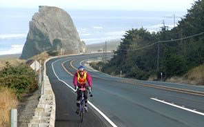
Those bicycling along the south Oregon and Northern California coasts will find less automobile traffic, wide shoulders, and lots of places to see and camp. Much of US 101 hugs the coast, offering amazing sights and views from the road. This is especially true during the last half of the trip.
First time visitors will be amazed at how nice the state campgrounds are that frequently offer dedicated camping areas and cater to the many cyclists enjoying the scenery.
Almost all cyclists travel from north to south, because of the prevailing winds, so the directions and information below assume that direction of travel – traveling south. Included are hints, suggested side trips and information about campgrounds and hotels.

Weather: The Oregon coast has about 6 months of sun and 6 months of rain. That is an oversimplification as there can be weeks in the winter when it is 60 degrees and sunny. However, the general rule is that the rains start on November 1, and then fade away in the spring. The driest months are July and August. September and early October can be wonderful. Warm and dry weather starts to phase in during March. Usually, by June it is mostly sunny.
The coast has perfect temperatures for cycling. The high usually does not exceed 70 degrees (21 C) during the day although it can get much warmer when traveling a short distance inland. During sunny days, the winds are from the north, so always travel south. When the wind comes from the south, it means that a storm maybe coming.
The south Oregon and northern California coast is preferred because there are more sunny days and less traffic. There are more campgrounds and secluded beaches making it easy to find a place to camp.
 For those wishing to make comments, suggestions or provide information, please feel free to . Or post your questions, photos and experiences on our Facebook page.
The towns are typically 25 miles apart in Oregon, making it possible to cycle to each one in a day. The topography changes dramatically with the northern part mostly flat and the section from Port Orford, through Gold Beach quite hilly and challenging.
It is also a challenging ride from Crescent City to Eureka, and is far longer than 25 miles. The trips are separated into section by section trips. Click on the links below for information.
Reedsport – Winchester Bay to Coos Bay
Ready for flat and sand? This maybe be the easiest portion of your trip. But take a couple of hours and rent an ATV and explore the dunes – which you cannot do by biking. Also, don’t miss the lighthouse near Winchester (fresh seafood, yum!). More information…
Coos Bay – Charleston to Bandon
South of Coos Bay, the sand dunes disappear. Don’t cycle out of Coos Bay and south here. Take a side route and go out to Charleston (more fresh seafood, yum!), plus Cape Arago. Then there is a route to the south that will bring you back to Route 101. More information…
Bandon to Port Orford
Just north of Bandon is a state park which is great for camping. Bandon has Old Town, which is worth a stop (even more fresh seafood near the dock!), plus a creamery located right on US101. South of Bandon, the route if away from the coast. Stop at Langlois for hot dogs (no seafood). Then camp at Cape Blanco. Or cycle through Port Orford and go to Mt. Humbug State Park. More information…
Port Orford – Gold Beach to Brookings
The bike from Port Orford to Gold Beach is a bit more challenging. Be sure to stop at Port Orford and cycle around the fishing boats for a view unlike other ports – they are up and out of the water! Then enjoy the views and hilly challenges to Gold Beach. Be sure to hit Otter Point. Stay at Gold Beach for a night, and take a ride on the jet boats. Rest up for perhaps the hardest part of the trip, from Gold Beach to Brookings, which is also the most scenic part of the trip. More information…
Brookings – Harbor to Crescent City
South of Brookings, it gets flat again. Vier off towards Harbor (more seafood!) and stay along the coast as long as you can. Then flat to Crescent City and the Redwoods! More information…
Crescent City – Klamath to McMinnville – Arcata – Eureka
Until now, the towns have been about 25 miles apart. But the distance between Crescent City and Eureka is much further. The good news is that there are several campgrounds in the Redwoods, so careful planning is necessary. One of the steepest hills is south, right out of Crescent City, so rest up. More information…