 Because the south Oregon and northern California coast is relatively undeveloped, it offers an opportunity where birders on vacation can observe wildlife that rarely encounters people. It is located within the Pacific Flyway and as a result, there are more than 450 species of migratory birds that may be spotted.
The Oregon Islands National Wildlife Refuge is also located here and is the highest density of offshore islands and rocks, a habitat for over 1 million nesting seabirds. Also of special interest to Birders is the Bandon Marsh National Wildlife Refuge and the South Slough National Estuarine Research Reserve. Crescent City is home to the California Redwood Birding Trail and the International Migratory Bird Day.

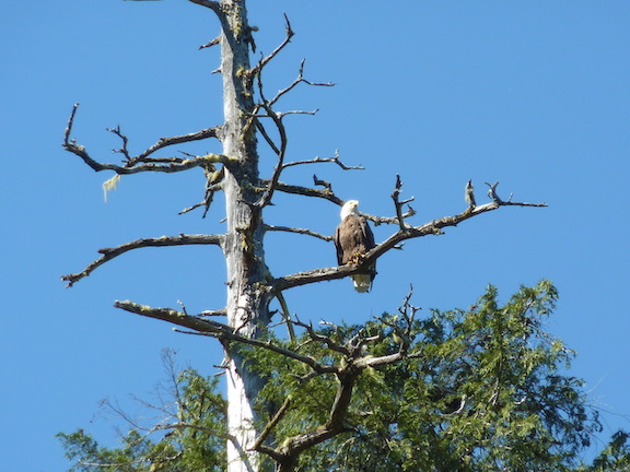
Look for the Red-tailed Hawk, Peregrine Falcon, Bald Eagle, Hutton’s Vireo, Spotted Towhee, Northern Flicker, Greater White-fronted Goose, American Dipper, Downy Woodpecker, Winter Wren, Red-breasted Nuthatch, Chestnut-backed Chickadee, Varied Thrush, Song Sparrow, Common Merganser, White-crowned Sparrow, Golden-crowned Sparrow, Dark-eyed Junco, and…
For detailed descriptions of birds and the best places to go birding, see Oregon Coast Birding Trails.
Download a PDF about birding. This brochure, provide by the Oregon Coast Birding Trail identifies over 50 sites for birder.
Download a PDF the complete Catalog of Oregon Seabird Colonies from the U. S. Fish and Wildlife Services.
Coos Bay – Charleston
Birders are in for a special treat. In addition to several trails and state parks in the area, Charleston is the home to the South Slough National Estuarine Research Reserve.
South Slough National Estuarine Research Reserve
 The South Slough National Estuarine Research Reserve (South Slough NERR) is 4,800 acres encompassing a mixture of open water channels, tidal and freshwater wetlands, riparian areas, and forested uplands. Take a walk through the woodlands to view Winter Wren, Wrentit, Spotted Towhee, Ruby-crowned Kinglet, Violet-green Swallow, Yellow-rumped Warbler, Sharp-shinned Hawk and Red Crossbill (among others). There is a boardwalk through the marsh that offers sightings of Greater Yellowlegs, Great Egret, Bufflehead, Double-crested Cormorant, Osprey, White-tailed Kite, and Bald Eagle.
 The Interpretive Center offers exhibits, educational programs, trail guides, and bird checklists.
The reserve is located on Seven Devils Road between Charleston and US 101.
For more information about the South Slough NERR, visit their website.
Bluebill Lake Trail
 Bluebill Lake Trail is an easy 1 & 1/4 mile hike around Bluebill Lake. The forty-acre lake is dry much of the year, but the hike offers ample opportunities to view wetland habitat. The hike is located next to Bluebill Campground.
Directions: From Coos Bay / North Bend, proceed north on route 101 for 1.5 miles. From Reedsport, proceed south for 22 miles. Turn west at the Horsfall Dunes and Beach road sign at Jordan Cove Road and proceed 1 mile, turning right on Transpacific Highway. Travel 100 feet, turning right on Horsfall Beach Road. Travel 1 & 1/2 miles down Horsfall Beach Road to a left turn. Download a PDF of the trail.
Bandon
 Just north of town is one of the best places on the coast for bird watching: the Bandon Marsh National Wildlife Refuge, which is located on the Pacific Coast Flyway.
Bandon is also home to the Shoreline Education for Awareness organization. SEA, Inc., which is an all-volunteer non-profit organization that has grown in influence and support, reaching 10,000 visitors annually.
Bandon Marsh National Wildlife Refuge
 The Bandon Marsh National Wildlife Refuge is a favorite for fishing, hunting, clamming and birding. The marsh is located just north of town, on the west, prior to the Bullards Drawbridge.
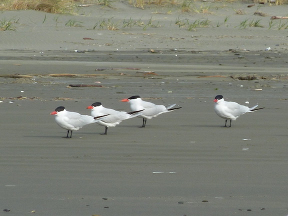
Bird species include the California Brown Pelican, the Pacific Golden Plover, Semipalmated Plover, Black-bellied Plover, Red Phalarope, Western and Least Sandpiper, Whimbrel, and Dunlin.
The refuge is 889 acres and is one of six National Wildlife Refuges along the Oregon Coast and is part of the Pacific Flyway.
Coquille Point
 Coquille Point is an excellent place to watch seabirds and harbor seals. The point overlooks a series of offshore rocks that provide habitat for seabirds such as the Western Gull, the Tufted Puffin, the Common Murre and the Brandt’s Cormorant. Along the rocks are Harbor seals and occasional Sea Lions.
There is a paved walking trail that features interpretive panels with information about the wildlife in the area as well as local Native American history. Stairways access the beach on opposite sides and this allows hikers to make a loop of the beach during mid to low tides.
Notable offshore rocks include Table Rock on the north, Middle Coquille Point Rock in the center, and Elephant Rock on the south.
Coquille Point can be accessed from a parking lot where 11th street ends at the ocean in Bandon.
As with all wildlife, be certain to stay away form the seals and Sea Lions. Do not touch seal pups. If they appear abandoned, leave them alone. The mother will return with food to feed the young.
Download a PDF of a map of the Coquille Point.
Floras Lake – Boice-Cope County Campground
 The lake is not the only attraction, as it is fed by a river that travels through a protected habitat of the brown pelican, the snowy plover, as well as many other species of birds. Kayakers have the opportunity to travel up into the river to view the birds as well as other wildlife. Boating with and without motors is allowed.
Gold Beach – Port Orford

A favorite of birders is to take one of the jet boats up the Rogue River where eagles, falcons and other birds that fish the river are in abundance. The less traveled Sixes and Elk Rivers are also favorites of bird watchers
Lola Lake is a little known small lake located south of Gold Beach, just south of Pistol River. Lola Lake is wet even during the dry season, but is overgrown and swamp-like, making it a perfect place for nesting and migrating birds and birders. The hike is short as the total distance around the lake from the parking area is just over a mile (1.7 km).

The challenge to get to the lake is not the fairly easy hike, but the parking. There is not an official parking area, but a well used spot on the west side of US Highway 101, just north of the 341-mile marker and south of Pistol River. The parking area is immediately at the end of a guardrail. There is a fairly sharp drop off from the paved highway into a sand and dirt area. Luckily, there are two southbound lanes, which makes it a bit safer to slow down to look for the pull off.
Lola lake is located just north of Crook Point and the bird sanctuary of Saddle Rock – also known as Mack Reef. While Saddle Rock is more famous, it is also essentially unreachable by land. If hiking past Lola Lake to the beach, the beach stops shortly to the south in a fortress-like point. There are fences on the land marked as “No Trespassing” in order to keep people from getting near the refuge. To the south of Crook Point is private property that was planned to be developed as a golf course.
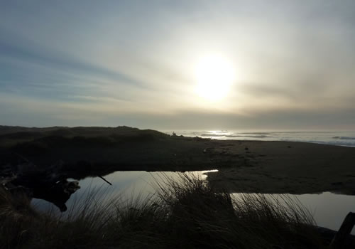
There are also scenic points at Cape Sebastian, Otter Point, Cape Blanco, among others that offer excellent opportunities for birding. Perhaps the best birding is along the coast from Gold Beach to Brookings [see Brookings Harbor, below].
Brookings – Harbor
To go bird watching near Brookings – Harbor, most travel north along US Route 101 to the Samuel H. Boardman State Scenic Corridor to see marine birds. Common and rare birds, such as the slaty-backed gull, can be found along the coast. Yet don’t miss the other opportunities along the Chetco River or in the Oregon redwoods.
Samuel H. Boardman State Scenic Corridor
 The stunning Samuel H. Boardman Scenic Corridor is a 12-mile stretch along the coast, of forested park with its spectacular coastline, rocky outcroppings, and smooth, sandy beaches. Starting with Arch Rock to the north, there are several spots for birders to look out for shore birds. These breathtaking views are easily accessed from US Highway 101. Harris Beach State Park is just north of Brookings.
The Samuel H. Boardman Scenic Corridor starts just north of Brookings Harbor and continues to about half way to Gold Beach.
For more information, download a brochure of the park.
Crescent City, CA
 Crescent City and Del Norte County, California, are a haven for birders. Del Norte County is home to California’s most northwestern redwood forest as well as Tolowa Dunes and Lake Earl, all havens for birders. In addition, the area is home to the California Redwood Birding Trail and the International Migratory Bird Day, which celebrates birds throughout the Americans.
Del Norte County is unique in that approximately 80% of the land is protected and undeveloped and it is home to Smith River, which is the nation’s longest Wild and Scenic River. It is also home to Lake Earl which is the largest coastal lagoon outside of Alaska. Del Norte County is also home to Alan Barron who has identified 420 species of birds in Del Norte County. He also identified 160 different avian species in a single day.
Castle Rock Wildlife Refuge
 Castle Rock Wildlife Refuge is a must see for birders. It is the second largest seabird colony in California and the third largest in the lower 48 states.
May through July is the best time to view breeding of the sea birds. There are spectacular fly-offs at dawn.
There are more than 80,000 seabirds nesting and breeding on the island of at least eleven species.
To reach the refuge, follow signs to the airport from route 101 near Crescent City. Turn left on Pebble Beach Drive. Parking and interpretive signs are almost immediately on your right.
Tolowa Dunes and Lake Earl
 The 5,000 acre Tolowa Dunes State Park and the 6,134 acre Lake Earl Wildlife Area are some of the finest wetlands habitats in the state. The park and wildlife area include wood ridges, wetlands, ancient sand dunes, and ocean beaches. The park serves as an important stopover for the Pacific flyway, the west coast bird migrations route, and features a diverse bird population. Lake Earl is mostly freshwater while Lake Tolowa has a higher salt content. Surrounding the lakes are saltwater marshland, freshwater wetlands, and sand dunes.
Hundreds of species of birds can be photographed, including
the rare Canada Aleutian goose, canvasbacks and the Peregrine falcon. Sea lions and harbor seals and gray whales can be spotted along the coast.
 Lake Earl has been included in an effort to restore grebe habitat along the coastal flyway. Lake Earl is the only coastal nesting area for grebe between British Columbia and Santa Barbara. Educational kiosks have been installed to inform the public of the grebe habitat that consists of floating island-nests on the lake. The grebe live on island nests in order to swim down and get fish, plus they have limited mobility on land. Boaters, kayaks and canoes are required to stay away from the grebes’ floating nests.
The Tolowa Dunes State Park is located north and south of the Lake Earl Wildlife Area.
There are two primitive campgrounds and includes a ride-in horse camp within the State Park. Off road, or ATV use is not allowed.
A directional map of the Lake Earl Wildlife Area is available.
Directions: From Crescent City, California, turn onto Northcrest Drive north from The Pacific Coast Highway US 101. From Northcrest Drive, access roads are Old Mill Road and further along Northcrest Drive (which becomes Lake Earl Dr.) turn left on Lower Lake Road to Kellogg or Pala Roads.
Download a kmz file for use in Google Earth to see the hiking area.
Eureka
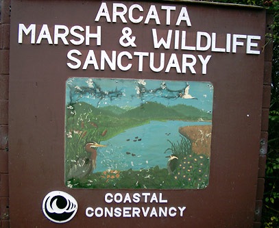
North of Eureka at the north exit for CA 255 exit 713, is the Arcata Marsh Interpretive Center which is located on the Pacific Flyway. With over 330 species of birds that travel through this area, the marsh is a prime spot for birding. It is considered to be the best place place to bird in Humboldt County and ranks 20th in the United States for species diversity. There are over 225 acres that are open to the public.
The Arcata Marsh Interpretive Center on 569 South “G” Street in Arcata has a bookstore, free maps and literature, interpretive displays, bird lists and log of recent bird sightings.
Humboldt Bay National Wildlife Refuge which includes Castle Rock National Wildlife Refuge, was established in 1971, to conserve precious habitat for the great diversity of birds, mammals, fish, amphibians, invertebrates, and plants that occur along the Pacific Coast of northern California.
The refuge has several different units totaling almost 5,000 acres and is located around and near the Arcata, Humbolt and South Bays north, west and south of Eureka.