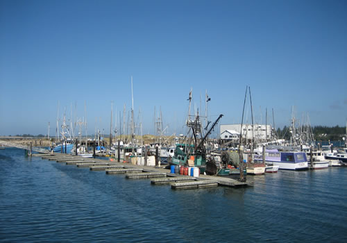
Charleston, a working fishing village, is located 10 minutes away from Coos Bay, to the west and is well worth the visit. Major attractions include the nearby Cape Arago, Shore Acres and Sunset Bay State Parks, which offer camping, beaches, whale watching, hiking, and views of the ocean.
Just north is the Oregon Dunes National Recreation Area with ATV trails and rentals available.
Take some time to travel the area and be certain to take a side trip over to charming Charleston and the coast and the surrounding State Parks. Plus the world famous Bandon Golf courses are a short distance south.
Charleston

Charleston is well worth the diversion off of Route 101. Watch as the fishermen work the sea, much as they have for centuries. It is also home to several restaurants that feature the freshly caught bounty of the ocean.
While in the area, stop at Bastendorff Beach County Park, Sunset Bay State Park, Shore Acres, Cape Arago State Park and lighthouse – all offering amazing views of the Pacific and excellent places to enjoy the unspoiled coast and all it has to offer.
If driving south on Route 101, follow the signs to Shore Points while driving through North Bend / Coos Bay.
If traveling north on Route 101, look for a left turn (west) approximately 7 miles north of Bullards Bridge north of Bandon onto W Beaver Hill Road, which becomes 7 Devils Road into Charleston.
Bastendorff Beach
 Bastendorff Beach is a county campground, day use area and beach. There are restrooms and coin-operated showers.
For reservations, call 541-396-3121 x354.
There are picnic areas and a fish cleaning stand. For group activities, there are two picnic shelters with kitchens and a fire pit – barbecue.

Bastendorff Beach is located directly west of Charleston, just north of the Cape Arago Lighthouse. Also nearby is Shore Acres, Sunset Bay State Park, and Cape Arago State Park.
Sunset Beach
Sunset Beach is located on Cape Arago Highway, on the way from Charleston to Cape Arago and Shore Acres. It is a beautiful beach naturally protected by the cove. The water is warmer than most because it is protected from the ocean currents. It is a favorite for picnics and wading into the water. There is plenty of parking available immediately off the road.
Shore Acres State Park
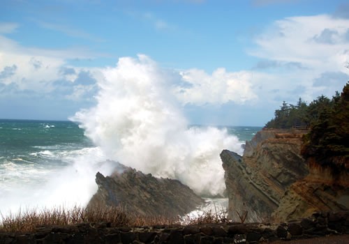
Shore Acres State Park is an Oregon State Park located near Charleston on the Pacific Coast. It was originally a private estate with luxurious gardens developed by the shipbuilder Louis J. Simpson. Today, the gardens have been fully restored with thousands of tulips, daffodils, rhododendrons, azaleas and flowering annuals/perennials. A fully enclosed observation building offers stunning views of towering storm waves and glimpses of migrating whales.
For more information visit the Shore Acres State Park website.
Cape Arago Lighthouse
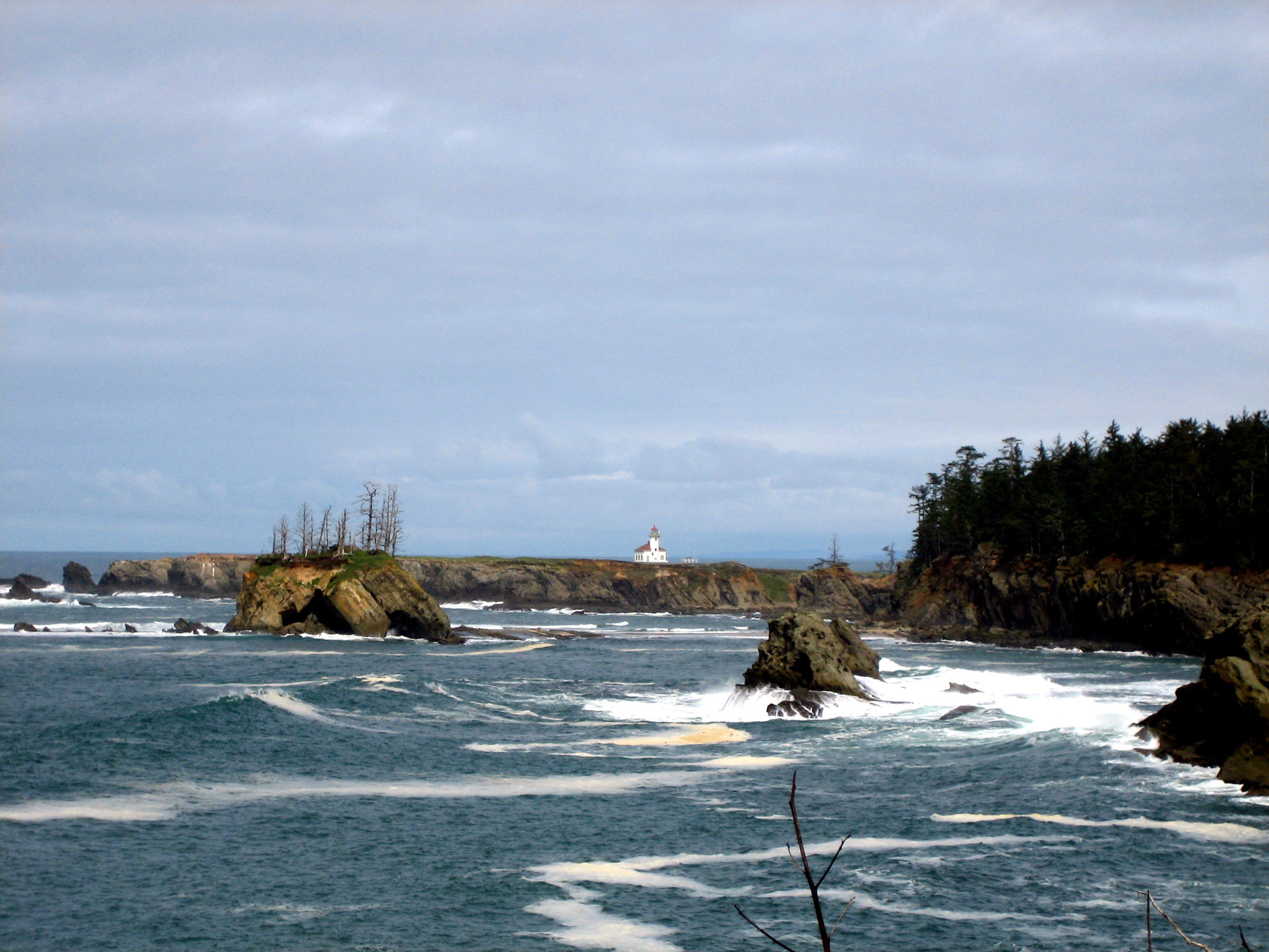
Cape Arago Lighthouse was constructed in 1889 and it was decommissioned in 1993. The Coast Guard removed the Fresnel lens from the tower, and placed it on display at Coast Guard Air Station North Bend. On January 1, 2006, the light was discontinued. The lighthouse is not open to the public. In November 2012, the high bridge leading to the lighthouse was removed in order to prevent unauthorized access to the island and to return the shoreline to a more natural condition.
This is probably the most difficult Oregon coast light to find, but the lighthouse can be viewed from various points along the coast south of the lighthouse. The best viewpoints maybe on the way into Shore Acres State Park. You might be able to get a closer view of the lighthouse by hiking up to the end of the bluff on the north side of the beach. However according to some accounts, these trails are not well maintained and may be quite dangerous.
In 2008, a bill was passed transferring the Cape Arago Lighthouse to the Confederated tribes of the Coos, Lower Umpqua and Siuslaw Indians. According to the legislation, the tribes must make the Light Station available to the general public for educational, park, recreational, cultural, or historic preservation purposes.
Cape Arago State Park
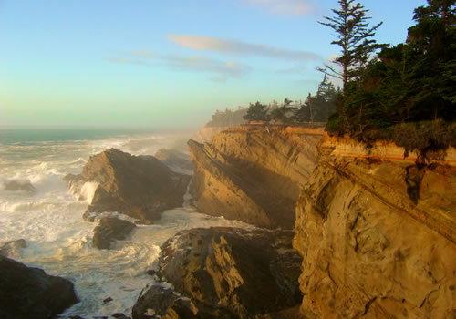
Cape Arago State Park has hiking trails, picnic tables, opportunities for tidepooling and viewing marine life, including whales, sea lions and seals. North of the park, on the way in, is the Simpson Reef interpretive stop offering the opportunity to view the sea mammals from the new viewing deck.
Volunteers are frequently at this viewing area to answer questions and loan out their sighting scopes.
Cape Arago State Park at the end of Cape Arago Highway about 15 miles southwest of Coos Bay and just a few miles southwest of Charleston. On the way to this park, be certain to stop at Shore Acres State Park and Sunset Bay. Save some time to stop at many of the fine restaurants located in Charleston that specialize in fresh seafood.
Shell Island
Shell Island on the way to Cape Arago offers a wonderful viewpoint to watch the sea lions sunning themselves.
Conde B. McCullough Memorial Bridge
 The Conde B. McCullough Memorial Bridge, which crosses Coos Bay, is one of the most beautiful and well-known bridges along the Pacific coast.
The bridge was completed in 1936 and spans the Coos Bay shipping channel. It is a cantilever construction and its designer, Conde McCullough, emphasized architectural beauty through the use of a graceful concrete and steel structure of Art Deco design that flows across the open water.
US Route 101 crosses Coos Bay on the bridge. Because the bridge and the walkway are narrow, cyclists are required to dismount and walk across the bridge.
Lakeside
 Lakeside is home to Tenmile Lake, one of the finest freshwater fishing lakes on the coast and one of the largest in the state. Species include: bluegill bullhead, largemouth bass, cutthroat and rainbow trout . Steelhead run the creek in the spring and fall which feeds the ocean.
The famous Lakeside Crawdad Festival is held each year in early May, usually on Mother’s Day weekend.
The July 4th weekend brings Drag Boat Races and all the excitement surrounding the holiday weekend.
The lake is also a favorite for water skiing, sailing and swimming. The Oregon Dunes are just across Route 101 from the lake.
Spinreel Campground, which caters to ATV users, is located on Tenmile Creek downstream from Tenmile Lake.
Lakeside, Oregon, located south of Winchester Bay, about midway between Coos Bay and Reedsport.
The Bay of Coos Bay
The Port of Coos Bay is the largest and deepest port between San Francisco, California and the Columbia River. The Conde B. McCullough Memorial Bridge, one of the most beautiful bridges on the coast, carries Route 101 over the bay.
Coos Bay Map
View Coos Bay Sightseeing in a larger map