The Oregon Coast Trail

The section of the Oregon Coast Trail from Arch Rock to Brookings, through the Samuel H. Boardman State Scenic Corridor, is one of the most beautiful hikes in the world. It is also one of the most accessible as it routinely touches US 101 with ample parking. Portions are flat and easily hiked. Other parts can be quite steep and there is at least one part on a beach that can be crossed only at low tide.
The award winning Walt Schroeder has written a mile by mile guide of the trail. Download the PDF here.
A mile by mile map of the hike is available here.
More information is available at the visitor centers along the coast and through the Oregon State Parks website.

The trail proceeds south of Brookings and into California where it (more or less) meets up with the California Coast trail. In this section, the hiking proceeds along back roads that parallel US 101. It travels through the unincorporated Harbor and onto Oceanview Drive. It meets up at US 101 just north of the Winchuck and ends at the Visitors Center at Crissey Field and the state line. This is one of the least interesting sections of the trail as most of it is along the road.
Download a PDF of this portion of the hike.
Day Hiking the Oregon Coast Trail north of Brookings
Selected Day Hikes from Arch Rock to House Rock
The best area to day hike starts at Arch Rock and continues down to Harris Beach, just north of Brookings.
If two cars are available, a great day hike is from Arch Rock to Thomas Creek Bridge. There is ample off road parking in both area.
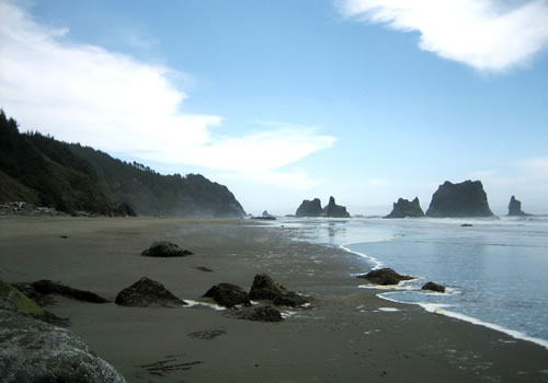
Arch Rock, Spruce Island, Secret Beach, Thunder Cove, Natural Bridge to China Beach

After traveling south past Pistol River, the coast trail hikes along US 101, until an unofficial parking lot north of Arch Rock. Those wishing to shorten this hike a bit can just park in the Arch Rock parking lot.
This section of trail is fairly flat (with exceptions) and remains on cliffs above the ocean. There is spectacular scenery and viewpoints along the way.
North of Arch Rock, the trail dips down a bit and nears the beach, but remains off the sand, then returns near to US 101. There is a rock outcropping and view above the beach just north of Arch Rock.

Arch Rock is one of the most spectacular viewpoints along this hike. After Arch Rock, the trail skims along the cliffs to Spruce Island Viewpoint, a short distance away. From there, the trail continues out to a cape which should not be skipped (but there is a cutoff), then swings back to US 101 and down to Secret Beach.
Secret Beach is not a secret, but there are three beaches, two of which are only accessible at low or minus tides. The trail climbs out to Thunder Cove viewpoint which has a view of the third and least accessible ‘secret’ beach. On the way, there is another hike out to a ‘do not miss’ cape, and then to the Thunder Cove parking lot.
The trail continues to the temperate rainforest and onto the Natural Bridges parking lot. South of the parking lot is the view of the Natural Bridge. It is possible to take a not marked side trail to the bridge and walk across the bridge. The hike down is steep and the bridge is narrow, so this is a dangerous side hike.
After the bridge, there is a peaceful hike through the rainforest, and then back along the road. The trail then takes a westward track uphill and back into the trees for a short distance, then back to US 101, staying along the road barrier, to the north China Beach Access.
Download a GPX of this hike for use in your GPS. Download a KMZ file for use in Google Earth.
Note, if file will not download, then right-click and select ‘download linked file’.
China Beach
China Beach is a nearly deserted section of beach north of Brookings that makes a wonderful, if challenging day trip. The trail head(s) are off of US Route 101. The trail is a steep descent down the north of south section of the beach, and the steep hike out is what helps to keep this a rarely used public beach. There is a rock outcropping in the middle of this section of the coast trail that is, perhaps, impossible to cross at high tide. To insure access, plan for low tide.
If hiking from north to south, the south trail exit is easy to miss. It should be marked by a post placed in the rocks, but storms regularly remove this marking. The exit is about halfway from the rock outcropping and the south end of this beach.
Download a GPX of this hike for use in your GPS. Download a KML file for use in Google Earth.
Note, if file will not download, then right-click and select ‘download linked file’.
Thomas Creek Bridge to Harris Beach
 As above, a great day hike involves two cars. One at Thomas Creek and the other at House Rock.
From the Thomas Creek Bridge parking lot, south of the bridge, hike south towards Brookings. The trail routes through the trees and out to viewpoints, but the best part starts with Indian Sands. Not only is Indian Sands a major archeological site (digging, removal of artifacts and defacing is illegal), but there are there are beautiful views from there.

After Indian Sands, hiking continues through the temperate rain forest with occasional ocean views. Just north of Whaleshead Beach, there are views south, to the beach and out to House Rock. Hike down to the beach and picnic area. Hiking along the beach becomes more private as heading south. At the south end, there is a fairly steep hike back up to the road. Then the trail heads down to House Rock.
House Rock is so named for a rock that looks a bit like a house, and there are more amazing views. The trail continues to Cape Ferrelo, then onto Lone Ranch. After Lone Ranch, the trail continues through the park, but then has to skip private property and the hike follows the road, so Lone Ranch is the end of the scenic portion.
From there, the trail gradually descends down to Harris Beach.
Download a GPX of this hike (through Whaleshead Beach) for use in your GPS. Download a KML file for use in Google Earth.
Note, if file will not download, then right-click and select ‘download linked file’.
The Oregon Redwood Trails #1107 and #1106
 Redwood Trails #1107 and #1106 are day use trails in this small section of preserved old growth Oregon Redwoods. Located a short distance south and inland of Brookings, and just north of the California State Line, this U. S. Forest Service Park offers a chance to see the redwoods away from the crowds.
These two trails are part of the same system and leave from the same parking lot. #1106 is wheelchair accessable and is 0.5 miles (0.8 km) long. #1107 is 1.2 miles long, is well maintained with a few challenging grades. The Forest Service grades this hike as “difficult with steep grades”, but it is not a challenge for hikers. The tallest trees are 350 feet (110 meter) and taller. There is a standing but hollow old growth redwood with a walkway into it.
From Brookings, travel south on US Route 101 to Route 896. Travel for 1.5 miles (2.4 km) to Forest Service Road 1101. The trail head is at the end of this road. There is parking, a picnic area and a restroom.
Download a GPX of this hike (through Whaleshead Beach) for use in your GPS. Download a KML file for use in Google Earth.
Note, if file will not download, then right-click and select ‘download linked file’.
For more information, see the Forest Service website.
Chimney Camp Trail #1279
 Chimney Camp Trail is an easy, almost flat hike along Wheel Creek and offers several picnicking and swimming spots. The entire trail can be hiked all year, except for the the northern most part of the trail, that crosses the creek. During the rainy months, crossing the creek is difficult and can be dangerous. Hiking during this time of the year should be from the south trail head. The trail is about 5 miles round-trip.
The south trail head leaves from near the Ludlum House and Ludlum Campground. Ludlum House is a group-use rental facility that requires advance reservation.
South Trailhead: From Brookings, take US Route 101 south to Route 896 – Winchuck Road (the same turn for the Oregon Redwood Forest). Follow to Forest Service Road 1107, to 1108. The trailhead is just past the Ludlum Campground on the east side of the Wheeler Creek bridge.
North Trailhead: From Brookings, take Route 808 (South Bank Chetco River Road) to Forest Service road 1205 (Mt. Emily Road) to the trailhead.