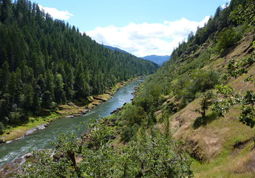
The Rogue River
The best way to experience the Rogue River is to take a ride on one of the Jet Boats. Fishermen should make plans to stop and fish, either by renting a boat, or signing up with one of the highly skilled river guides.
For those looking for an alternative, take a short 22 mile scenic loop on the north and south banks of the Rogue. The round trip crosses the Lobster Creek Bridge at its midpoint and is easy to drive or bike. There are ample opportunities to pull off and watch the osprey and bald eagles as they nest and dive into the river. Lucky visitors may catch a sight of a river otter or two. Closer to the mouth, harbor seals and sea lions abound.

There are several places to pull off the road and drive down to the river. The Lobster Creek Campground (on the south road near the Lobster Creek Bridge) offers paved access to the river. There are also several poorly marked unpaved roads to nearly isolated gravel bars (high clearance vehicle required).
Those with a bit more time should plan a trip up to Agness for lunch or dinner. The drive is about 50 minutes in each direction, but offers more exposure to the Rogue, the valley and the wildlife.
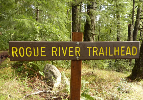
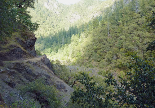
There is a new Rogue River Trail (not the same trail as the 40-mile trail along Agness and east) is located along the south bank. Look for several signs for hiking along the river.
Getting there: Approach the Rogue River Bridge in Gold Beach from either the north or south, turn east along the road along the river. The North Bank River Road (545) has at least two forks – always take the right one towards the river. Follow until the North Bank Road ends and bear right across the single lane Lobster Creek Bridge. Turn west on Jerry’s Flat Road (595) and return to Gold Beach.
Additional side trips: Take a few moments and visit the World’s largest Myrtlewood Tree. Just north of the single lane Lobster Creek Bridge, the now gravel North Bank Road (also known as Silver Creek Road, Forest Service road 3533) continues. Drive just a short distance (~1/4 mile) down this road and look for parking along the road and a trail on the left. The hike is a little steep but is short and not too difficult. Another side trip is a drive to the Frances Schrader Old Growth Trail, which many find almost as impressive as the Redwoods. This trail is located 2 miles up the narrow gravel road just to the south of Lobster Creek Bridge. While the road is gravel, it should be an easy drive for all vehicles. Look for a parking lot on the left. The hike is an easy and highly informative that the entire family can enjoy.
Rogue River map and float guide PDF.
Agness

Agness is a charming tiny (population: 113 in 2007) community located near the confluence of two Wild and Scenic Rivers—the Lower Rogue River and the Illinois River. The Agness area is popular for fishing and hiking. Agness is in the Siskiyou National Forest and was threatened by the Biscuit Fire in 2002.
Agness is served by one of only two rural mail boat routes still operating in the U.S. (The other is on the Snake River in Idaho). The mailboat runs on the Rogue River between Gold Beach and Agness during the summer months. The mail is delivered by road for the remainder of the year.

Rogue River Ranch, east of Agness, is on the National Register of Historic Places.
The travel to Agness is about 50 minutes from the Oregon Coast, but the drive has the added benefit of beautiful views of the Rogue river. From Gold Beach, turn east at the south end of the bridge to Jerry’s Flat Road (route 595 to NF-33). Follow for about 30 miles across the Illinois River bridge and the Rogue River bridge; turn left onto the Agness-Illahe Road for about 3 more miles.

An excellent way to visit Agness is via the Jet Boats. Try to eat lunch at one of the restaurants on the north side of the Rogue, as that is where Agness is located. There is usually enough time after eating to explore much of the area. The Old Agness Store is a moderate walk from the restaurants. While there, don’t miss the Agness-Illahe Museum, 34470 Agness-Illahe Road. Phone: 541 247 2014. Hours: 11 AM to 2 PM Daily May through September.
Agness has a K-6 “one-room school” that closed in September 2009.
Agness is a mecca for fishing, whitewater rafting and hiking. For those whitewater rafting, Agness is the end of the line, with the takeout point just a short distance up the Rogue River. For hikers, the Rogue River Trail ends here, while the Lower Rogue River trail starts.
For fishing, the Rogue and the Illinois Rivers combine just a short distance downstream. There are boat ramps, campgrounds (Agness RV Park, plus several nearby Forest Service campgrounds), plus a lodge (Lucas Lodge) and three small stores / restaurants.
For such a tiny town, there is a lot to see and do.